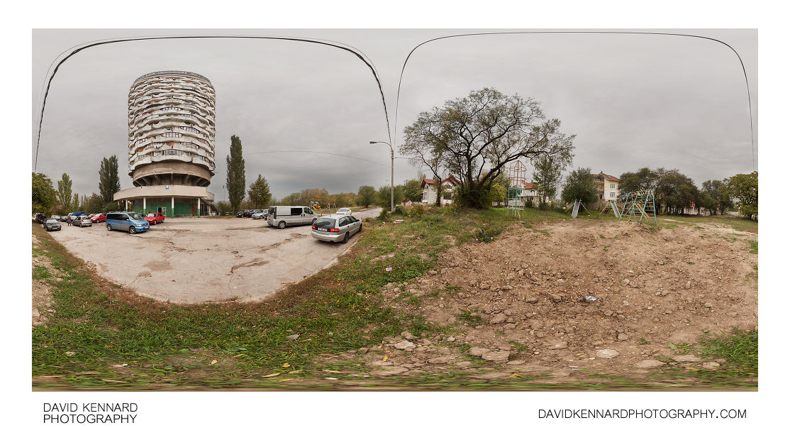
Romashka / Corncob building, Chişinău

Description
- Title:
- Romashka / Corncob building, Chişinău
- Caption / Description:
-
Panorama by the Romashka Tower in the Centru sector of Chișinău, Moldova. The tower is known for it's unusual architecture, designed by Oleg Vronsky. Construction of the project started in 1978, but stopped soon after. Originally designed as hotel / leisure facilities, the project was completed in 1984 with a change in use to housing.
The building's name, 'Romashka' («Ромашка»), means a camomile flower. It is also known as 'Stone Flower' ('Floare de Piatra') and 'Corn Cob' («кукурузный початок») as it resembles a camomile flower or a corn cob in some aspects.
The nearby soviet era playground is abandoned, but a new one has been built on the land just to the south of the building. The area in front of the building is used for parking. The adjoining road to the south-west is blocked off. The building has 22 floors, plus an additional section on top, which offers excellent views over the local area.
- Tags / Keywords:
-
- Europe
- Panorama
- Cloudy
- Overcast
- Urban decay
- Soviet architecture
- Centre sector
- Centru
- Chişinău
- Corn Cob
- Floare de Piatra
- Romashka Tower
- USSR
- Ромашка
- кукурузный початок
- Moldova
- Chişinău Municipality
- Municipiul Chişinău
Admin
- Date Original Photo Taken:
- Original File Name:
- Romashka Tower.psb
- Event:
- Rating:
- ☆
- Date this image added/last updated on website:
- Original File Dimensions:
- 15980px x 7990px
- File Type:
- JPEG
- Color Mode:
- RGB
- Original Image Color Profile:
- Adobe RGB (1998)
Location
- Location Shown:
-
- Sublocation:
- Strada Arheolog Ion Casian-Suruceanu 29/2
- City:
- Chişinău
- Province/State:
- Municipiul Chişinău
- Country:
- Moldova, Republic Of
- World Region:
- Europe
- Location Created:
-
- Sublocation:
- Strada Arheolog Ion Casian-Suruceanu 29/2
- City:
- Chişinău
- Province/State:
- Municipiul Chişinău
- Country:
- Moldova, Republic Of
- World Region:
- Europe
- Geo-location:
- 46.990966666667, 28.836986666667 View on map
Rights
- Copyright Status:
- Copyrighted
- Licensing Status:
- Rights Managed
- Available for Editorial Use:
- Yes
- Available for Commercial Use:
- No
- Copyright Notice:
- © 2014 Dave Kennard
Camera Data
- Date Digital Resource was created:
- Shutter speed:
- 1⁄50 s
- Aperture:
- f/11
- Camera Model:
- Canon EOS 5D Mark II
- ISO:
- 400
- Exposure Compensation:
- 0
- Focal Length:
- 17mm
- Focal Length (35mm equiv.):
- 17mm
- Metering Mode:
- Multi-segment
- Flash:
- Off, Did not fire
- Exposure Mode:
- Manual
- White Balance:
- Manual
- Light Source:
- Exposure Program:
- Manual
Additional shooting metadata
- Lens:
- Tokina ATX107 DX FishEye 10-17mm F3.5-4.5
- Filters used:
- Additional Optics used:
- Setup:
- Benro C-428 Tripod
Nodal Ninja 3 II Rotator and lower rail
Nodal Ninja 3 vertical arm and upper rail
Arca Swiss Compatible Quick Release Clamp
Remote shutter release
6 shots around, 1 up, 1 down, 1 down handheld, all bracketed ±1.3EV
Post Processing
- Image Modified:
- Software used:
-
- Adobe Camera RAW
- PTGUI 9 Pro
- Adobe Photoshop 14
- Post Processing:
RAWs converted in ACR
Images stitched and blended in PTGUI 9 Pro
Stitching / blend issues fixed in PS CC
Images blended for exposure in PS CC
PF Removal
Curves adjustment to darken road and soil
LCE selectively applied
