Tapgol Park panorama
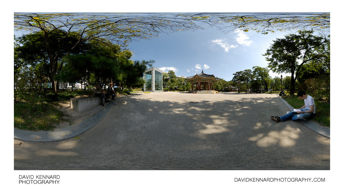
Tapgol Park panorama

Description

Title:
Tapgol Park panorama
Caption / Description:

Tapgol Park (탑골공원), in Jongno-gu, Seoul, South Korea. In the centre of the park is the Palgakjeong pavilion (팔각정) where the Korean Declaration of Independence was read on March 1st 1919, when Korea was under Japanese rule. To the north of the pavilion is a large structure holding the 10 storey stone pagoda of Wongaksa temple (원각사지십층석탑).

Tapgol Park was originally the location of Wongaksa temple (원각사), until the temple was closed by King Yeonsangun, who supressed Buddhism during his reign (1494-1506). It is unknown when the park was constructed, but it is believed to have been sometime during the 1890s, and was the first modern park to be built in Seoul. Its construction was first suggested by the Irishman John McLeavy Brown, who served as Inspector General of Customs under the government of Emperor Gojong.

The park has also been known as Pagoda Park, due to the famous 10 storey stone pagoda located there, but has been known by its official name Tapgol Park since 1991.

Tags / Keywords:
  • Asia
  • 한국
  • Hanguk
  • 韓國
  • Korea
  • Seoul Special City
  • Seoul Teukbyeolsi
  • 서울特別市
  • 서울특별시
  • 팔각정
  • 八角亭
  • Jongno-gu
  • 종로구
  • 鐘路區
  • Jongno 2(i)-ga
  • 종로2가
  • 鍾路2街
  • Tapgol Park
  • Tapgol Gongwon
  • 탑골 공원
  • 塔골公園
  • Pavilion
  • Palgakjeong
  • Ten storey stone pagoda of Wongaksa temple
  • Won-gaksaji Sipcheung Seoktap
  • 원각사지십층석탑
  • 圓覺寺地十層石塔
  • Wongaksa temple
  • 원각사
  • 圓覺寺

Admin

Date Original Photo Taken:
Original File Name:
Pano.psb
Event:
Rating:
Date this image added/last updated on website:
Original File Dimensions:
10520px x 5260px
File Type:
JPEG
Color Mode:
RGB
Original Image Color Profile:
Nikon Adobe RGB 4.0.0.3000

Location

Location Shown:
Sublocation:
Tapgol Park
City:
Jongno-gu
Province/State:
Seoul Special City
Country:
Korea, Republic Of
World Region:
Asia
Location Created:
Sublocation:
Tapgol Park
City:
Jongno-gu
Province/State:
Seoul Special City
Country:
Korea, Republic Of
World Region:
Asia
Geo-location:
37.571266993703, 126.98819713236 View on map

Rights

Copyright Status:
Copyrighted
Licensing Status:
Rights Managed
Available for Editorial Use:
Yes
Available for Commercial Use:
No
Copyright Notice:
© 2009 Dave Kennard

Camera Data

Date Digital Resource was created:
Shutter speed:
1125 s
Aperture:
f/8
Camera Model:
Nikon D200
ISO:
100
Exposure Compensation:
0
Focal Length:
10mm
Focal Length (35mm equiv.):
15mm
Metering Mode:
Multi-segment
Flash:
No Flash
Exposure Mode:
Manual
White Balance:
Manual
Light Source:
Cloudy
Exposure Program:
Manual

Additional shooting metadata

Lens:
Tokina ATX107 DX FishEye 10-17mm F3.5-4.5
Filters used:
Additional Optics used:
Setup:
Benro C-428 Tripod
Nodal Ninja 3 II Rotator and lower rail
Nodal Ninja 3 vertical arm and upper rail
Arca Swiss Compatible Quick Release Clamp
Remote shutter release
6 shots around, 1 up, 1 down, 1 down handheld, all bracketed ±1EV

Post Processing

Image Modified:
Software used:
  • Nikon Capture NX
  • Nikon Capture NX 2
  • Adobe Photoshop CS5
Post Processing:

NEFs converted with -0.3 exposure compensation in CNX2
Images (except handheld nadir) stitched and blended in PTGUI 9 Pro
Images blended for exposure in PS CS5
Nadir patched in PS CS5