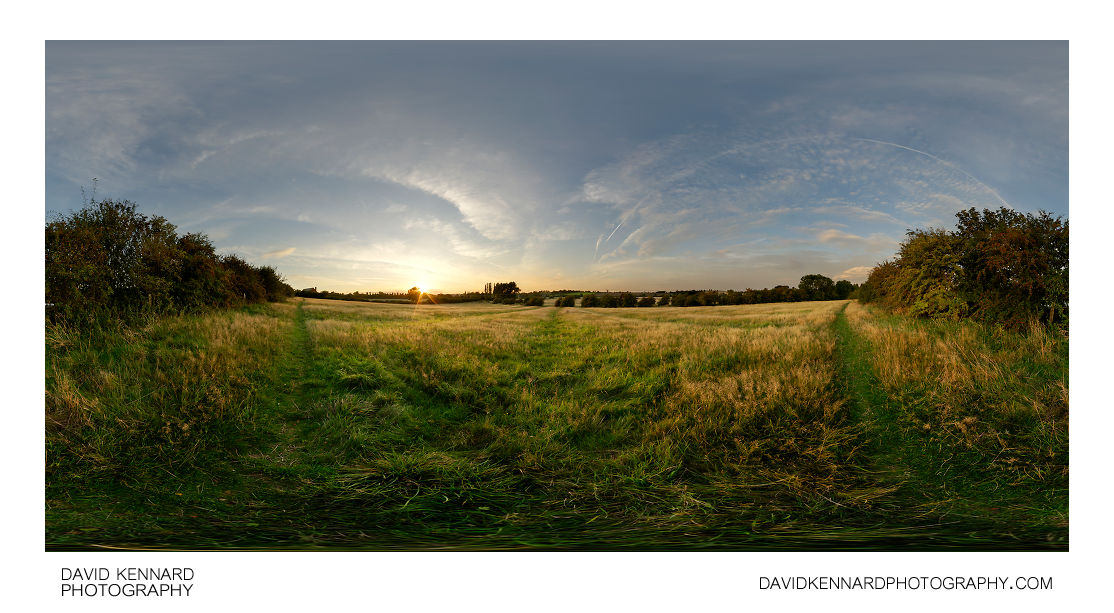
Ridge and furrow field at sunset

Description
- Title:
- Ridge and furrow field at sunset
- Caption / Description:
-
360° panorama of a ridge and furrow field between Market Harborough and Lubenham at sunset.
From Wikipedia (http://en.wikipedia.org/wiki/Ridge_and_furrow):
Ridge and furrow is an archaeological pattern of ridges and troughs created by a system of ploughing used in Europe during the Middle Ages. The earliest examples date to the immediate post-Roman period and the system was used until the 17th century in some areas. Ridge and furrow topography is found in Great Britain, Ireland and elsewhere in Europe. The surviving ridges are parallel, ranging from 3 to 22 yards (3 to 20 m) apart and up to 24 in (0.61 m) tall – they were much taller when in use. Older examples are often curved.
Ridge and furrow topography was a result of ploughing with non-reversible ploughs on the same strip of land each year. It is visible on land that was ploughed in the Middle Ages, but which has not been ploughed since then. No actively ploughed ridge and furrow survives.
- Tags / Keywords:
-
- Europe
- UK
- Britain
- England
- East Midlands
- Leicestershire
- Market Harborough
- Sunset
- Panorama
- Lubenham
- Ridge and Furrow
- Medieval farming
Admin
- Date Original Photo Taken:
- Original File Name:
- Ridge and furrow field at sunset.psb
- Event:
- Rating:
- ☆
- Date this image added/last updated on website:
- Original File Dimensions:
- 10508px x 5254px
- File Type:
- JPEG
- Color Mode:
- RGB
- Original Image Color Profile:
- Nikon Adobe RGB 4.0.0.3000
Location
- Location Shown:
-
- Sublocation:
- City:
- Market Harborough
- Province/State:
- Leicestershire
- Country:
- United Kingdom
- World Region:
- Europe
- Location Created:
-
- Sublocation:
- City:
- Market Harborough
- Province/State:
- Leicestershire
- Country:
- United Kingdom
- World Region:
- Europe
- Geo-location:
- 52.474409773511, -0.95088600842806 View on map
Rights
- Copyright Status:
- Copyrighted
- Licensing Status:
- Rights Managed
- Available for Editorial Use:
- Yes
- Available for Commercial Use:
- No
- Copyright Notice:
- © 2010 Dave Kennard
Camera Data
- Date Digital Resource was created:
- Shutter speed:
- 1⁄50 s
- Aperture:
- f/8
- Camera Model:
- Nikon D200
- ISO:
- 100
- Exposure Compensation:
- 0
- Focal Length:
- 10mm
- Focal Length (35mm equiv.):
- 15mm
- Metering Mode:
- Multi-segment
- Flash:
- No Flash
- Exposure Mode:
- Manual
- White Balance:
- Manual
- Light Source:
- Cloudy
- Exposure Program:
- Manual
Additional shooting metadata
- Lens:
- Tokina ATX107 DX FishEye 10-17mm F3.5-4.5
- Filters used:
- Additional Optics used:
- Setup:
- Benro C-428 Tripod
Nodal Ninja 3 II Rotator and lower rail
Nodal Ninja 3 vertical arm and upper rail
Arca Swiss Compatible Quick Release Clamp
Remote shutter release
6 shots round, 1 up, 1 down, 2 down handheld, all bracketed ±2EV
Post Processing
- Image Modified:
- Software used:
-
- Nikon Capture NX 2
- Adobe Photoshop CS5
- PTGUI 9 Pro
- Post Processing:
NEFs converted with -0.3 exposure compensation in CNX2
Images (except handheld nadir images) stitched, blended, and exposure fused in PTGUI 9 Pro
Handheld nadir images stitched in PTGUI 9 Pro
Exposure fused, EV-1, and EV+2 images blended in PS CS5
Nadir patched in PS CS5
Curves adjustment used to brighten nadir in PS CS5
Curves adjustment in soft light blend mode used to darken and add contrast to EV+2 images
Lens flare cloned out in PS CS5
LCE selectively applied in PS CS5
